
CA RxR 2.05: Route 1: Monterey, Santa Cruz, and the Santa Cruz Coastline

In Episode 2.05 of California Highways: Route by Route, we continue our exploration of Route 1 by exploring everything about the segment of Route 1 from Carmel in Monterey County to just N of the Tom Lantos Tunnels near Montara (in San Mateo Couny). This includes communities such as Carmel, Monterey, Seaside, Watsonville, Castroville, Aptos, Santa Cruz, the Santa Cruz Coastline, Half Moon Bay, and Montara.  As always, we go over the history of this segment of the route, the history of the route through various communities , the freeway plans, discuss relinquishments, names, and some current plans. We also talk in detail about the Devil’s Slide and the Tom Lantos Tunnels, as well as projects in Santa Cruz. Looking forward, episode 2.06 will continue our exploration of Route 1 with the portions between Pacifica to (and including) the city of San Francisco.

Here’s the link to the show:


And here’s the link on Spotify for Podcasters:

Here are some relevant links (I may edit this to add more links in later):

We encourage you to explore our back catalog through this site or our Spotify for Podcasters home.
Related Post

CA RxR 4.02: I-8 and US 80 Between El Cajon and the Arizona BorderCA RxR 4.02: I-8 and US 80 Between El Cajon and the Arizona Border

This is Episode 4.02, which continues our exploration of Route 8, better known as Interstate 8. In this episode, we focus on the portion of I-8 from La Mesa (just outside of San Diego) to the Arizona border. We look at not only current I-8, but the routing of the predecessor route, US 80. We discuss the communities of La Mesa and El Cajon, Alpine and Descanso, Boulevard, the Mountain Springs Grade, Jacumba, Ocatillo (with a digression on the Imperial Highway), El Centro, Holtville and the Algondenes Dunes (with a digression on the Plank Road), Winterhaven and Yuma. We also briefly talk about the interesting routing of US 80 within Arizona, and how it differs from I-8. We talk about historical routings, projects along the route, and some significant names. In the next episode, we’ll turn our attention to Route 9, which currently runs from Santa Cruz to Los Gatos, but which once ran all the way to Castro Valley.

Here’s the link to the show:

And here’s the link on Spotify for Creators:

(more…)

CARxR Ep. 1.03: Building a State Highway System: The 1930sCARxR Ep. 1.03: Building a State Highway System: The 1930s

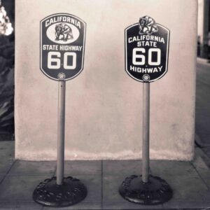
Proposed Auto Club State Route Signage

Proposed Auto Club State Route Signage

In this episode, we’re continuing to explore the history of the State Highway System, focusing on the 1930s and the early 1940s. This is part of our first season of California Highways: Route by Route, where we are exploring the background needed for our route by route journal. In this episode, we’ll see the establishment of the legislative route system, the creation of state sign routes and the signage by the auto club, a major expansion of the state highway system, and continuing growth on the Federal side, laying the groundwork for the eventual interstates. This episode also features an interview with Morgan Yates, Archivist of the Auto Club of Southern California. During his interview, Morgan shared a picture of alternative state routing signs proposed by the ACSC (included here thanks to the auto club). You can write to Morgan at: Corporate Archivist; Automobile Club of Southern California; 2601 S. Figueroa St., MS H-118; Los Angeles, CA 90007.

Here’s the link to the show:

And here’s the link on Anchor.FM:

(more…)

CA RxR 4.10: Route 12: Into the SierrasCA RxR 4.10: Route 12: Into the Sierras

Episode 4.10 concludes our exploration of Route 12 with an exploration of the final section of the route: From Route 99 in Lodi to Route 49 near San Andreas. This is a segment that travels through the foothills of the Sierras, running through Lodi, Lockeford, Clements, Valley Springs, and San Andreas along what was originally LRN 24. We also review LRN 12, which we visited before in our episodes on Route 8, for LRN 12 became I-8 between San Diego and El Centro. In our next episode, our attention turns to Route 13, and includes a discussion of LRN 13, the original Sign Route 13 which was quickly renumbered as Sign Route 17, and today’s Route 13 which runs through Oakland and Berkeley, although the route is unconstructed between the Oakland Airport and I-880.

Here’s the link to the show:

And here’s the link on Spotify for Creators:

(more…)