
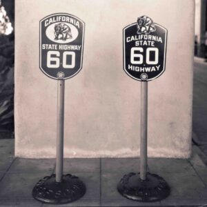
Proposed Auto Club State Route Signage
In this episode, we’re continuing to explore the history of the State Highway System, focusing on the 1930s and the early 1940s. This is part of our first season of California Highways: Route by Route, where we are exploring the background needed for our route by route journal. In this episode, we’ll see the establishment of the legislative route system, the creation of state sign routes and the signage by the auto club, a major expansion of the state highway system, and continuing growth on the Federal side, laying the groundwork for the eventual interstates. This episode also features an interview with Morgan Yates, Archivist of the Auto Club of Southern California. During his interview, Morgan shared a picture of alternative state routing signs proposed by the ACSC (included here thanks to the auto club). You can write to Morgan at: Corporate Archivist; Automobile Club of Southern California; 2601 S. Figueroa St., MS H-118; Los Angeles, CA 90007.
Here’s the link to the show:
And here’s the link on Anchor.FM:
Here are some relevant links for the episode:
- California Highways – Chronology: Phase II: Early Growth (1915-1932)
- California Highways – Chronology: Phase III: A Significant System is Created (1933-1946)
- California Highways and Public Works, August 1934 (where the State Sign Routes were announced)
- The Federal Urban Highway Program
- How SoCal’s Automobile Club Paved the Way For Road Development in the Name of Historic Preservation
- Before Paved Roads, There Is The Auto Club
- The History of Traffic Signing in California
- One Mile in Five: Debunking The Myth
- Building a Super-Highway: A Closer Look
We welcome your comments on the episode. We’re also looking for someone to donate or provide more appropriate theme music. We’re also looking for interviews for future episodes; if you know a good person for us to talk to, drop a note to daniel@caroutebyroute.org. In particular, we’re looking for the folks to talk about the following:
- For 1.05: Someone familiar with the Pat Brown era of road construction, who is also familiar with the impact on the state of the Great Renumbering (ideally, someone who remembers it first hand).
- For 1.06: Someone familiar with the contracting and development process for highways today: How the CEQA has changed the process, and the increasing role of regional transportation agencies.